-
Recent Posts
Tweets
- @geoestratego Reducir todo a malos y buenos es infantilizar el relato. Lo que si tengo claro es lo cobardes, oportu… twitter.com/i/web/status/1… 1 day ago
- @bob_duffy Because in modern life you have data engineers, pipelines and sinks, even when you are doing the same 🙊 2 days ago
- New alternative to locally validate database and query design together with client application code: #azuresql… twitter.com/i/web/status/1… 4 days ago
- I want to see who is the brave that combines #datavault in a #lakehouse in a project and bring it to production. St… twitter.com/i/web/status/1… 4 days ago
- In this video you can kick-off your #IaC journey and learn how to create an #ARM template from the azure portal, ed… twitter.com/i/web/status/1… 1 week ago
Archives
Categories
Meta
Blog Stats
- 273,784 hits
Category Archives: Open Data
Talend job to lookup geographic coordinates into a shape file
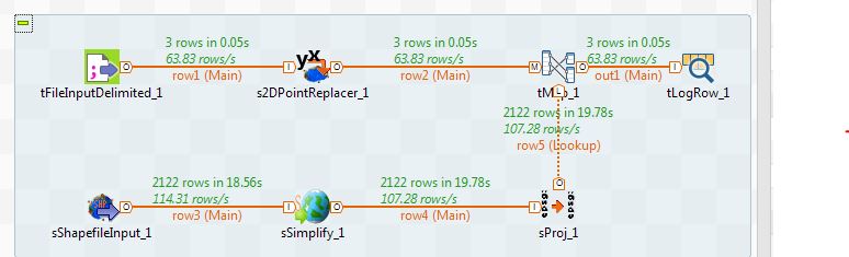
Introduction Recently for an open data integration project I had to select some tools in order to be able to process geospatial data. I had a couple of choices: I could use R and try to work out a solution … Continue reading
Posted in Business Intelligence, Geospatial data, Open Data, Talend
Tagged geospatialdata, opendata, spatialdata, Talend, tutorial
3 Comments